Cook Islands Kūki 'Āirani |
|---|
|
Anthem: Te Atua Mou E
(English: "God is Truth")
|
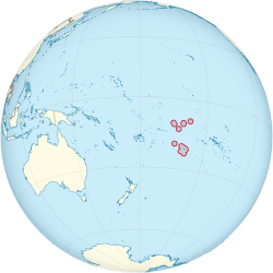 |
| Capital and largest city | Avarua
21°12′S159°46′W / 21.200°S 159.767°W / -21.200; -159.767 |
|---|
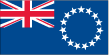
| Official languages | |
|---|
| Spoken languages | - English (86.4%)
- Cook Islands Māori (76.2%)
- Other (8.3%)[1]
|
|---|
| Ethnic groups | |
|---|
| Demonym(s) | Cook Islander |
|---|
| Government | Unitaryconstitutional monarchy |
|---|
|
| Elizabeth II |
|---|
| Tom Marsters |
|---|
| Mark Brown |
|---|
| Tou Travel Ariki |
|---|
|
| Legislature | Parliament |
|---|
|
|
| 4 August 1965 |
|---|
• UN recognition of independence in foreign relations | 1992[3] |
|---|
|
|
• Total | 236.7 km2 (91.4 sq mi) (unranked) |
|---|
|
• 2016 census | 17,459[4] (223rd) |
|---|
• Density | 42/km2 (108.8/sq mi) (138th) |
|---|
| GDP (nominal) | 2020 estimate |
|---|
• Total | US$384,000,000[5] (not ranked) |
|---|
• Per capita | US$21,994 (not ranked) |
|---|
| Currency | New Zealand dollar(NZD)
Cook Islands dollar |
|---|
| Time zone | UTC-10 (CKT) |
|---|
| Driving side | left |
|---|
| Calling code | +682 |
|---|
| ISO 3166 code | CK |
|---|
| Internet TLD | .ck |
|---|
|


_(Polynesia_centered).svg)