Republic of the Union of Myanmar - ပြည်ထောင်စု သမ္မတ မြန်မာနိုင်ငံတော် (Burmese)
- Pyidaunzu Thanmăda Myăma Nainngandaw
|
|---|
|
| Anthem: |
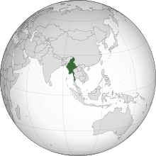 Show globe Show globe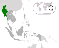 Show map of ASEAN Show map of ASEANLocation of Myanmar (green) in ASEAN (dark grey) – [Legend] |
| Capital | Naypyidaw[a]
19°45′N96°6′E / 19.750°N 96.100°E / 19.750; 96.100 |
|---|
| Largest city | Yangon[b] |
|---|
| Official languages | Burmese |
|---|
| Recognised regional languages | |
|---|
| Official script | Burmese script |
|---|
| Ethnic groups | |
|---|
| Religion | |
|---|
| Demonym(s) | Burmese / Myanma[5] |
|---|
| Government | Unitaryparliamentaryassembly-independentrepublic under a military junta |
|---|
|
| Myint Swe (acting) |
|---|
| Min Aung Hlaing |
|---|
| Soe Win |
|---|
|
| Legislature | Assembly of the Union |
|---|
| House of Nationalities |
|---|
| House of Representatives |
|---|
|
|
| c. 180 BCE |
|---|
| 23 December 849 |
|---|
| 16 October 1510 |
|---|
| 29 February 1752 |
|---|
| 1 January 1886 |
|---|
| 4 January 1948 |
|---|
| 2 March 1962 |
|---|
• Renamed from "Burma" to "Myanmar" | 18 June 1989 |
|---|
| 30 March 2011 |
|---|
| 1 February 2021 |
|---|
|
|
• Total | 676,578 km2 (261,228 sq mi) (39th) |
|---|
• Water (%) | 3.06 |
|---|
|
• 2017 census | 53,582,855 (2017)[6] (26th) |
|---|
• Density | 76/km2 (196.8/sq mi) (125th) |
|---|
| GDP (PPP) | 2021 estimate |
|---|
• Total |  $258 billion[7] (63rd) $258 billion[7] (63rd) |
|---|
• Per capita | $4,830[7] (142th) |
|---|
| GDP (nominal) | 2021 estimate |
|---|
• Total | $78 billion[7] (71nd) |
|---|
• Per capita | $1,422[7] (160th) |
|---|
| Gini (2017) |  30.7[8] 30.7[8]
medium |
|---|
| HDI (2019) | 0.583[9]
medium · 147th |
|---|
| Currency | Kyat (K) (MMK) |
|---|
| Time zone | UTC+06:30 (MMT) |
|---|
| Driving side | right |
|---|
| Calling code | +95 |
|---|
| ISO 3166 code | MM |
|---|
| Internet TLD | .mm |
|---|
- ^ Also spelled "Nay Pyi Taw".
- ^ Also spelled "Rangoon".
|


.svg)
_ASEAN.svg)