Territory of Palmyra Atoll |
|---|
Incorporated territory of the United States |
 Flag |
| Etymology: Greek: Παλμύρα |
| Anthem: The Star-Spangled Banner |
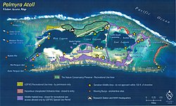 Visitor Access Map of Palmyra Atoll
|
 Location of Palmyra Atoll in the Pacific Ocean |
| Coordinates: 5°53′1″N162°4′42″W / 5.88361°N 162.07833°W / 5.88361; -162.07833Coordinates: 5°53′1″N162°4′42″W / 5.88361°N 162.07833°W / 5.88361; -162.07833 |
| Country |  United States United States |
|---|
| Status | Incorporated unorganized territory |
|---|
| Annexed by the U.S. | June 14, 1900 |
|---|
| Named for | American trading ship Palmyra |
|---|
| Government |
|---|
| • Type | Administered as a National Wildlife Refuge |
|---|
| • Body | U.S. Fish and Wildlife Service of the U.S. Department of the Interior |
|---|
| • Superintendent | Laura Beauregard, Pacific Remote Islands Marine National Monument |
|---|
| Area |
|---|
| • Total | 11.9 km2 (4.6 sq mi) |
|---|
| • Land | 11.9 km2 (4.6 sq mi) |
|---|
| • Water | 0 ha (0 acres) 0% |
|---|
| Dimensions |
|---|
| • Length | 4.7 km (2.9 mi) |
|---|
| • Width | 6.8 km (4.2 mi) |
|---|
| Elevation | 2.1 m (7 ft) |
|---|
| Highest elevation (Sand Island) | 10 m (30 ft) |
|---|
| Lowest elevation (Pacific Ocean) | 0 m (0 ft) |
|---|
| Population (2019) |
|---|
| • Total | 4–20 staff and scientists |
|---|
| | Temporary researchers |
|---|
| Time zone | UTC−11 (Samoa Time Zone) |
|---|
| Geocode | 127 |
|---|
| ISO 3166 code | UM |
|---|
| Currency | US dollar (USD) |
|---|
| Website | www.fws.gov/refuge/Palmyra_Atoll/ |
|---|
|
|
| Designated | 2001 |
|---|
|
|---|
|
|---|
| Official name | Palmyra Atoll National Wildlife Refuge |
|---|
| Designated | April 1, 2011 |
|---|
| Reference no. | 1971[1] |
|---|
|
|---|
|
|---|
|

.svg)

.svg)