Johnston Atoll
Kalama Atoll |
|---|
|
|
| Anthem: "The Star-Spangled Banner" |
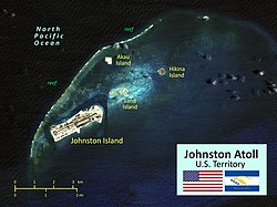 Map of Johnston Atoll |
Location in the North Pacific Ocean |
| Coordinates: 16°44′13″N169°31′26″W / 16.73694°N 169.52389°W / 16.73694; -169.52389Coordinates: 16°44′13″N169°31′26″W / 16.73694°N 169.52389°W / 16.73694; -169.52389 |
| Country | United States |
|---|
| Status | Unorganized, unincorporated territory |
|---|
| Claimed by U.S. | March 19, 1858 |
|---|
| Government |
|---|
| • Type | Administered as a National Wildlife Refuge |
|---|
| • Body | United States Fish and Wildlife Service |
|---|
| • Superintendent | Laura Beauregard, Pacific Remote Islands Marine National Monument |
|---|
| Area |
|---|
| • Total | 1.03 sq mi (2.67 km2) |
|---|
| • EEZ | 157,389 sq mi (407,635 km2) |
|---|
| Highest elevation (Sand Island) | 30 ft (10 m) |
|---|
| Lowest elevation (Pacific Ocean) | 0 ft (0 m) |
|---|
| Population (2007) |
|---|
| • Total | 0 |
|---|
| Time zone | UTC-10 (Hawaii–Aleutian Time Zone) |
|---|
| Geocode | 127 |
|---|
| ISO 3166 code | UM |
|---|
| Website | www.fws.gov/refuge/Johnston_Atoll/ |
|---|

.svg)

